
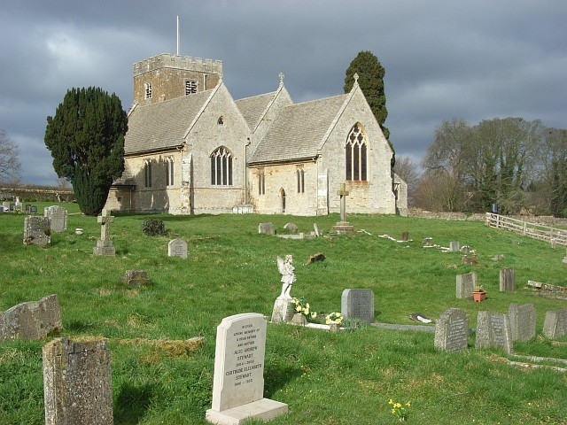
Steeple Barton is a civil parish and scattered settlement in West Oxfordshire, England, lying on the River Dorn roughly 8.5 miles (13.7 km) east of Chipping Norton, a similar distance west of Bicester, and 9 miles (14 km) south of Banbury. The parish covers 2,906 acres (1,176 ha) of mainly limestone uplands, cut through by the Dorn and its tributaries, notably the Cockley Brook. Although the parish carries the name Steeple Barton, most of its 1,546 residents live in the village of Middle Barton, about 1 mile (1.6 km) to the northwest of the older Steeple Barton settlement. That shift in population has its roots in the catastrophic mortality of the Black Death in 1349, which emptied the original village and sent survivors to found what became Middle Barton.
Key facts
- Country: United Kingdom
- Type: village; civil parish
- Located in: West Oxfordshire
- Coordinates: 51.9220, -1.3510
- Population: 1,546
Geography and Layout
The parish spans 2,906 acres (1,176 ha) of limestone upland country in West Oxfordshire. The River Dorn and the Cockley Brook cross the land, breaking the otherwise open plateau into a patchwork of fields and farms. The main road between Bicester and Enstone, now classified as the B4030, runs through the parish on an east–west alignment; it was turnpiked in 1793 and disturnpiked in 1876.
Despite the parish’s name, the settlement of Steeple Barton itself amounts to a scattered collection of farms and cottages. The village of Middle Barton, about 1 mile (1.6 km) to the northwest, holds the bulk of the population. Earthwork humps visible in the surrounding fields mark where the original, larger Steeple Barton village once stood before the 14th century depopulation.
History
The area’s occupation stretches back well before medieval settlement. Mosaic pavements discovered during tree-planting works in the parish, recorded by George Alexander Cooke in the Topography of Great Britain (1829), point to Roman activity on the limestone uplands.
The medieval village of Steeple Barton suffered more severely from the Black Death than almost anywhere in the region. In 1349 all 32 villein yardlands of the manor lay fallow and uncultivated because the villeins had died. By 1352 the number of untenanted yardlands had grown to 46, as any replacement tenants also failed or never arrived. Survivors relocated to the more central ground that became Middle Barton, leaving the original site to revert to farmland. The township of Steeple Barton was enclosed perhaps as early as the 14th century, while the open fields of Middle Barton survived until parliamentary enclosure in 1796.
By 1801 the parish contained 1,824 acres of arable land, 932 acres of grass, and 143 acres of woodland. Population climbed through the 19th century, from 393 in 1801 to a peak of 956 in 1871, before falling back to 651 by 1901. In the later 19th century, small-scale industry appeared on the landscape: a brick works near Whistlow Farm and three lime kilns, one of them at Maiden Bower.
Barton Abbey and Its Garden
The principal country house in the parish carries the name Barton Abbey, though that name rests on a mistake. Around 1860 the house was renamed on the false assumption that the Augustinian Osney Abbey had a cell there; no such cell existed.
The garden surrounding the house covers 15 acres and includes sweeping lawns, a lake, a walled garden with yew hedges and espalier fruit, woodland paths, and working glasshouses. It opens periodically under the National Garden Scheme.
The Hoar Stone
A large sandstone boulder known as the Hoar Stone sits near Steeple Barton within a small mound of about 30 feet across at grid reference SP458241. The stone measures approximately 11 feet (3.2 m) in length.
Church and Parish
The church of St Mary the Virgin serves the Barton Benefice, a grouping that encompasses Westcote Barton, Steeple Barton, Duns Tew, Sandford St Martin, and Over with Nether Worton. St Mary is the largest of the six churches within the benefice.
Did you know
- The Hoar Stone was broken up for road stone by a tenant farmer in 1843. The new owner of Barton Abbey, Mr H. Hall of the Hall’s Brewery family, gathered the broken pieces together and enclosed them with iron railings; those railings have since disappeared. (historicoxfordshire.ashmolean.org)
- In 1349, at the height of the Black Death, every one of the 32 villein yardlands of Steeple Barton manor lay fallow and uncultivated because all the villeins had died. By 1352 all 46 yardlands were in the same condition for lack of tenants. (british-history.ac.uk)
- In the mid-19th century, many of the women of Steeple Barton parish found employment stitching gloves for manufacturers in the nearby town of Woodstock, a cottage industry recorded in A Topographical Dictionary of England (1848). (british-history.ac.uk)
- The 1377 poll-tax returns show that Sesswell’s Barton, part of the parish, was then its most populous settlement with 57 contributors, while Steeple and Middle Barton together had only 55, reflecting the uneven impact of the Black Death decades earlier. (british-history.ac.uk)
Data sources
- Wikidata
- british-history.ac.uk
- steeplebartonparishcouncil.org
- wikishire.co.uk
- ngs.org.uk
- megalithic.co.uk
- forebears.io
- achurchnearyou.com
Data updated: 2026-10-30